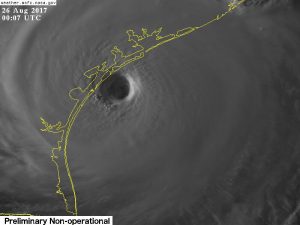
All eyes are on the unfolding catastrophe in Texas this coming weekend. Major Hurricane Harvey is hitting the coast near Corpus Christi as of this typing with sustained winds of 130 mph. The storm will be epic in terms of financial losses – never mind the personal loss and desperation that will continue for weeks, months, years. Here’s a picture of the hurricane from our newest satellite in orbit, GOES 16, just as it was making landfall.
The tragedy to come will be the torrents of rain. Some of our more reliable models show up to 5 FEET of rain may fall through Tuesday as the storm listlessly wanders between Houston and Corpus Christi.
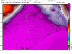
Part of the reason for the meandering is that upper level winds – which normally steer a hurricane – are absent across much of Eastern Texas in the coming days. The hurricane has literally moved into a dead zone in that sense. As a result, it will have to “rain itself out”, releasing mind-boggling amounts of water in the process. Certainly those who chose to wait out the storm are in deep peril, with some likely to succumb to drowning in the face of that much water.
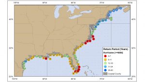
In terms of risk, some are saying that after decades of waiting – Harvey may be the worst Texas hurricane since Carla in 1961 – the coast of Texas was due for a biggie. Well, that’s not necessarily so. Oddly enough, South Coastal Texas is about as likely to see a hurricane as Southern New England!
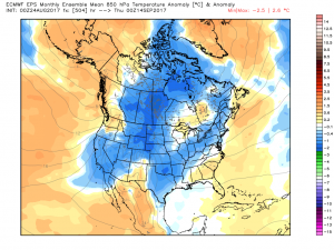
Speaking of, the weather has turned cooler across the Northeast and Great Lakes as of late, and that seems poised to continue in the near term. The same pattern that will stall Harvey in Texas will also keep the Upper Midwest and Northeast high and dry in the near term.
Harvey aside, the tropics are relatively quiet in the Atlantic and Eastern Pacific. That allows us to settle into a somewhat stable pattern across the Northern Hemisphere. That includes more cool intrusions into the Upper Midwest and Northeast along with more heat in Western Canada – possibly sneaking into Alaska in the 15-20 day period.
The focus in the coming weeks – and by default in this blog – will revolve around establishment of an autumn pattern. As past years have shown, this will be an opportune time to pick very warm locations deep into October and November, with very few opportunities for cold air to become established due to decreased Arctic ice coverage and limited early season chill.