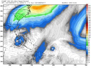
This week, Florida was in the crosshairs of one of the strongest hurricanes ever recorded in the Atlantic Ocean basin. It was spared the full fury of a Category 5 (the highest on a scale of 1-5) after Irma made brief landfall in Cuba Saturday. A slightly weaker storm then turned north around a nosy high pressure system (seen with the clockwise winds east of Miami in the following picture) and pummeled the Keys in the wee hours of Sunday morning.
As is typical in the immediate aftermath of a hurricane, reports of damage and devastation will take a while to surface. That’s often because of the lack of communication brought about by power outages. As of this typing, over 5 million are without power in Southern and Central Florida – a number sure to climb in the coming days.
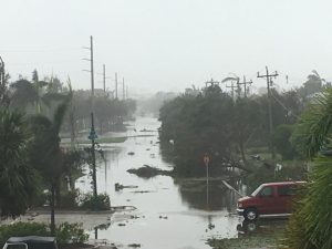
Marco Island after second landfall in Florida:
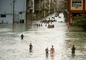
And flooding in Havana from the first Cat. 5 hurricane in Cuba since the 1920s:
With two hurricanes clobbering different parts of the United States, please keep those who are less fortunate in your thoughts. Donations and support will go a long way in the coming weeks and months.
The long range, the pattern remains fairly stable. Frequent intrusions of cold into the Lower 48 over the last few weeks seem to be on the wane as the cold hovering over the North Pole flops over to the Eastern Hemisphere.
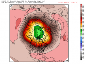
Note the green coloring. Typically this time of year the colder air starts to build near the Pole and fills in across Siberia and Northern Canada. Like many years past, the cold is favoring Siberia, leaving Nunavut and the Northwest Territories of Canada to wallow in the warmth through late September. This area seems ripe for above normal temperatures, and with sustained cold absent, there may be some record heat possible in some locations. It’s not often that we see this kind of consistency in the weather models – and with such a vast area of above normal temperatures, it’s open season on autumn warmth in Canada.
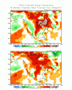
My personal take is anything from Slave Lake, Alberta to Moosonee, Ontario is fair game for anomalous warmth into early October. While the area is expansive, I often turn to the MJO to narrow (and highlight) the focus a little more. As the MJO moves from the Maritime Continent to the Western Pacific
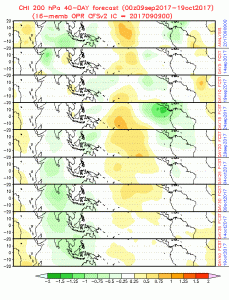
the focus for the warmth will turn to the Great Lakes and Northeast. This provides a hint as to where the focus for the warmth would be in Canada too. It’s for this reason that I’d favor more warmth in the the Great Lakes and Ontario than I would toward Alberta and Saskatchewan. We’ll see how this plays out in the weeks ahead.