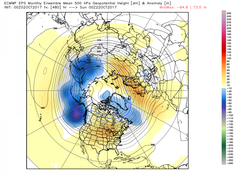
The page turns, and October is upon us. Like many who forecast in the long range, our company is focused on the unfolding winter pattern. Is it dominated by the evolving La Nina, or will we see high latitude blocking hold the Northern Hemisphere hostage?
If we were to follow the emerging snowpack, one would see that this autumn is already following in the footsteps of the last three in establishing early season snow in Siberia.
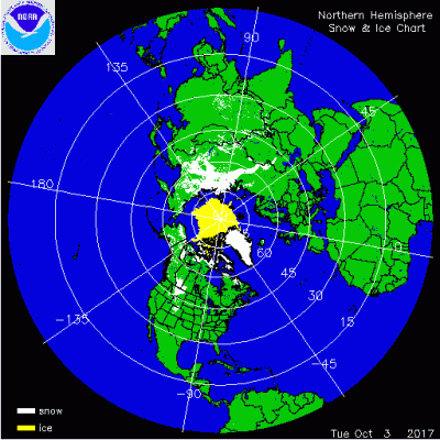
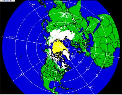
Compare that to two years ago in mid-October, and you clearly see the slant towards an early-season snowpack establishing in Siberia.
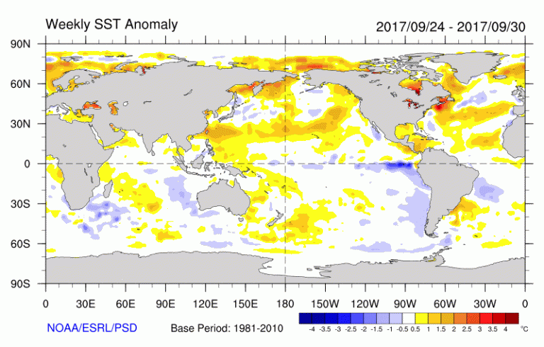
Meantime in the tropics, La Nina continues to hold sway (as denoted by the deep blue anomalies along the equator).
Given these two major controls of climate, it appears we have our players for the upcoming cold season. While those two elements alone could drive the pattern in the coming months, we’d be remiss if we didn’t include the Arctic Oscillation (AO) and its role in high latitude blocking.
Right now the AO is slightly positive, but will trend toward negative in the next couple of weeks. This in turn will increase the snowcover across Siberia, creating a feedback to more blocking in the weeks leading up to the start of meteorological winter (Dec 1st- Feb 28th). Judah Cohen, who blogs biweekly for AER on the AO and Polar Vortex, points out that this holds the key to the start of winter in the Northern Hemisphere.
“With the AO/NAO predicted to be negative at least up to the third week of October confidence is growing that October Eurasian snow cover will be above normal once again this year. Above normal snow cover favors a strengthened Siberian high and a weakened polar vortex/negative AO this upcoming winter with cold temperatures across the continents of the NH.”
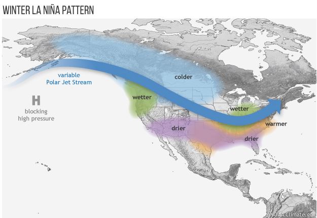
Essentially, this points to frequent arctic intrusions into the Lower 48 with periods of bitterly cold air. Timing these out will be tricky, depending on the state of the blocking and whether or not La Nina will strengthen. In all honesty, with a stronger La Nina, the intrusions could be longer and more frequent since La Nina events reinforce the cold in Western Canada and the Northern Plains.
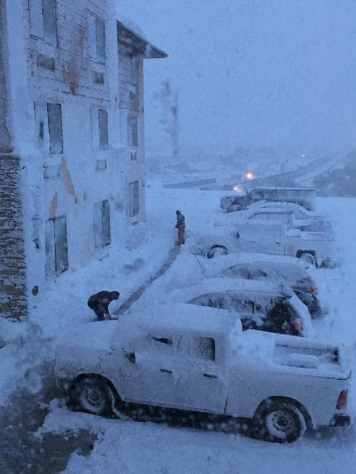
Of course, the wheel is just beginning to turn, and there is much to be played out in the coming months. But when looking at the past week and the coming two weeks, there is a clear trend toward cold air burrowing into the Intermountain West. In fact, a cold pocket of air and a lot of what is known as “upslope” moisture yielded a record 13″ of snow in Havre, Montana on Oct. 3rd as blizzard conditions hit parts of the state. The highest snow totals were around 30″ in Rocky Boy, Montana.
Just as they dig out, there are signs the cold may back off but just in the short term. A deep area of low pressure – with colder than normal temperatures – will pool in the Gulf of Alaska in the next 2-3 weeks.
This could be the impetus for more cold to pour into the Northern Rockies and Western Canada. In turn, the warmer air will shift east to the Great Lakes and Ontario. The GFS model has been struggling with the western cold, but it seems to be adamant about the warmer air in the Lakes and south central Canada.
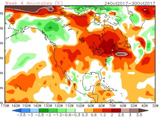
That’s a lot of warm air! And backed by the aforementioned climate controls, confidence is running high in the extended range.