Besides the fact that summer is on life support across the Lower 48 – with the exception of the recent blurb of heat in the Southwest and coming heat wave in Montana and the Dakotas – the big story of the week is the deep, cool low pressure system poised to crash into the West by week’s end.
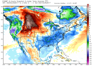
Shown is the temperature anomaly (deviation from normal) for late Friday. Note the huge surge of heat into Montana, Saskatchewan and the Dakotas. Also note the cool air in the Eastern 2/3 of the country and the unusually cold air entering the Pacific Northwest.
This is summer, so the heat is expected in some respect. But the recent cold snaps have been both significant and consistent. And while some are already calling this the year without a summer, there is still plenty of summer ahead and plenty of time to revert to the proverbial dog days.
Plenty of finger pointing has been going on in the direction of the Northern Pacific – namely the strength and persistence of the Aleutian Low – semi permanent feature off the coast of Alaska’s Aleutian Islands. Typically a salient feature in the winter, it shrivels and retreats in the summer months as the subtropical high asserts itself.
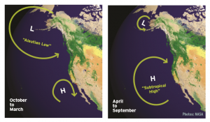
This year, however, its strong showing in the early part of summer has some scratching their heads as it drives the weather pattern over North America. Indeed, the upcoming spell of cool weather in the west is a result of the Aleutian Low injecting cold air across the west.
The obvious question becomes, why is this happening and will it continue this month?
Part of the reason for the continued strength of the Aleutian Low is the colder than normal sea surface temps (SSTs) in the Gulf of Alaska. For those new to SST anomalies, it is widely know that in the extratropics, weather patterns drive the SSTs. In the tropics, however, SSTs drive the weather patterns. (This is easily understood by looking at El Nino and La Nina: those variations of the Southern Oscillation steer the weather patterns for months – or even years – at a time.)
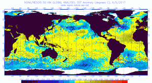
As shown above, the North Pacific is abnormally cold this month, a perfect place for a cold Aleutian Low to fester and subsist. As SSTs are slow to evolve and decay, it is my opinion that we are in for more cold outbreaks in the West for the remainder of June – offset by a quick warm-ups to near or above normal conditions.
Predicting the pattern out 20 days and beyond is difficult, but with an abnormally strong Aleutian Low calling the shots and the Madden Julian Oscillation (MJO) playing Jekyll & Hyde in the deep tropics, we have found a diamond in the rough this June: a semi-predictable pattern that we can sink our investment teeth into.