In past weeks, we’ve been discussing the consistency in the forecast in regards to timing the warm and cool spells across North America. This week, a new player has emerged as a dominating feature in the global weather models.
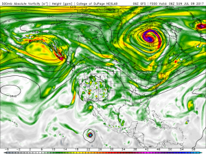
Note the yellow, gold, violet and magenta-colored feature in Eastern Canada. That’s an upper level low pressure system. It is typically associated with cool, cloudy weather (or very cold, somewhat snowy weather in winter), and has been a persistent feature on the long range weather maps. With such a large, anomalous low spinning in the atmosphere, our forecasts for the next 20+ days will revolve around tracking its movements over North America.
This low is associated with the Arctic Oscillation, which has been running positive since the middle of last month.
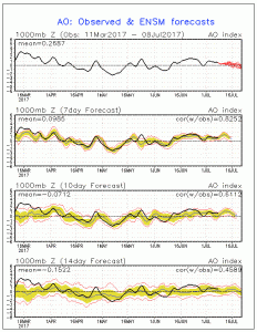
Although the forecast is showing a slight downward tick into mid/late July, I have reason to believe that our friendly upper low will not be going anywhere anytime soon. Lows of this size and magnitude don’t simply drop off the weather maps in a week’s (or two) time. The require a major shift in the pattern – on that is unlikely during the summer.
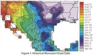
The rise of this “anchor” in the atmosphere has strengthened the high pressure system in the West and finally given rise to the Southwest Monsoon. With nearly half of the Southwest’s annual rainfall at stake, the monsoon has been very prompt in recent years – one of the few elements of consistency in the weather pattern as of late.
With two stable features in the atmosphere (high and low pressure), and the weather pattern in its usual slow down period of summer, this again seems like a good time to find opportunities for above and below normal temperatures. In the very long range period of 20+ days, there seems to be more heat focused in the Pacific Northwest and Western Canada than in other parts of North America.
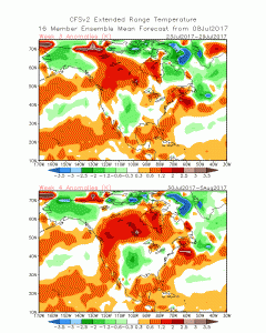
While the latest GFS model forecasts erode the upper low in Eastern Canada and project warmth to infiltrate Quebec and Labrador, I have my doubts about how quickly the cool air will dissolve. In the West however, the models have overlapped on the heat, leading me to believe that there will be plenty of above normal days coming as we head into the midsummer. In the East, the weather will be more volatile. Frequent cooldowns and warmups are at the mercy of expansion and contraction of the upper low. We are also watching the MJO as it reaches into the Maritime Continent in the coming weeks. This could signal an uptick in tropical cyclones in the Pacific, which would in turn make the forecast more unpredictable in the long range period.