With summer peaking across the Northern Hemisphere, our thoughts turn to heat, drought and the threat for tropical cyclones (Not necessarily in that order).
While last week’s blog focused on the cold, deep low pressure system in Eastern Canada, this week we focus on its counterpart: a mountainous ridge of hot high pressure over the Southern Plains.
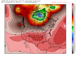
While not causing record heat, it is driving the monsoon over the Desert Southwest. And its placement over the Lower 48 in the 20 day forecast period is key to searing heat and a continuation of the rainy season for Arizona and New Mexico.
So far this week, the models have had a hard time nailing down whether the high will center over Eastern Colorado or Western Utah. With a position in either location, the monsoon is likely to see a bit of a lull across the deserts as the source region of the moisture (Mexico and the Gulf of California) are cut off at the pass.
Heat will once again flood the Intermountain West in the long range, as the Eastern US and Canada see suppressed summer warmth – with occasional forays into cooler than normal weather.
On of the major reasons for the warm pool of high pressure shifting out of the Southern Plains and towards the West is the deepening drought across the High Plains and Canadian Prairies.
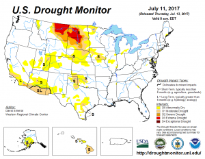
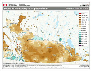
As the old adage goes: dry begets dry. And in this case, dry begets heat. The drift of this high back over dry land sets up a feedback loop that sustains the high pressure system. It typically takes a seasonal shift in the pattern to break the cycle. Until that shift comes, confidence remains high that the drought will continue to deepen throughout the remainder of summer and perhaps into early fall.
The Madden Julian Oscillation (MJO) remains a weak forcing feature in the extended range. Tropical activity is suppressed for now – with possible uptick in Atlantic activity expected in early/mid August as the MJO moves into the Western Hemisphere and the East warms under an extending Bermuda High. I not bold enough to say there is a threat for a landfalling hurricane on the Eastern Seaboard, but with all the elements aligning for heightened tropical activity, it’s wise to be vigilant.
Certainly a few things to keep us busy as summer enters it’s third and final month.